
“At St. Thomas, the town is the island and the harbor is the town.” William Gifford Palgrave
St. Thomas, with its deep natural harbor and strategic location, has been an important center for shipping and trade for centuries, and its success can be attributed to the many wharves available for easy access.
The wharves, in particular, played a significant role in the island’s history, allowing for the ease of loading and unloading of cargo.
They were a vital link in the transportation of goods between the Old World and the New World.
A Scenic View of the Harbor
- When combined, the two images above, form an impressive panorama of the town and harbor of Charlotte Amalie.
- Major wharves and dock facilities are notated in the photographs, but there is otherwise precious little information about these pictures.
- With some sleuthing, it is possible to determine the story behind the photograph of the wharves, or as we would say in Virgin Islands English Creole, ‘The St. Thomas Wharf Dem’.
A ‘Swing Lens’ Panorama
A careful examination of the harbor pictures reveals they are actually 2 parts of a panoramic photograph.
Covering approximately 90 degrees, this photo was taken near the great house at Estate Mafolie with a specialized panoramic camera.
- The camera lens swung in an arc exposing film that was loaded on a similarly curved arc in the back of the camera.
- George Eastman’s (Kodak) manufacture of a flexible celluloid film starting in 1889 made the development of swing lens panoramic cameras more practical by the early 1890s.
- This technology for panoramic photographs allowed for a wide field of view perfect for this type of vista.
This has been surpassed only over the last two decades of digital photography with its increasing megapixels and improved photo editing software to ‘stitch’ photos together to form a panorama.
Assigning a Date To the Photograph
Dating from 1895 or earlier, this photograph of the St. Thomas harbor represents an effective use of cutting-edge technology for the time.
The detail in the town of Charlotte Amalia allows one to identify individual buildings, such as the A. H. Riise Apothecary at No. 6 Dronningens Gade (Main Street).
The Apothecary suffered major damage due to candles causing a Christmas tree to catch fire in December 1895.

The structure was rebuilt with two stories instead of the original three.
In the panorama, the Apothecary clearly has three stories.
Given the type of camera and clues from the picture, the photograph was likely taken between the early 1890s and December 1895.
Edward Fraas-Photographic Artist
Edward Fraas published this panorama in his booklet ‘Souvenir of St. Thomas’ in 1897.
The souvenir booklet contains two panoramas.
- The St. Thomas harbor panorama would later be used for a folding postcard and other versions where just a portion of the photo was used.
- The other panorama, a view of the hills of Charlotte Amalia from De Beltjen Road, is another classic Fraas photograph of St. Thomas.
Fraas was a photographer who emigrated from Denmark to the Danish West Indies in 1863.
He later obtained his Borgerbrev (Burgher brief) as a merchant in Charlotte Amalia.
When he passed away in 1913, his island photography career spanned 50 years.
Edward Fraas was a pioneer in photography and postcard publishing in St. Thomas.

What’s in a name?
The photograph at the beginning of this post is notated with certain wharves and undeveloped waterfront properties.
Any of these properties deserve a detailed write-up, but the following brief overview will have to suffice for now.
The wharves and properties are listed as such:
1. Floating
2. Slippen
3. Floating
4. Dr. Mortensen
5. Miss Knight
6. French Wharf
7. Liverpool Wharf
8. German Wharf
9. Brønsted & Co. Wharf
10. Royal Mail Company Wharf

The Floating Dock anchored off of Hassel Island was able to service ships in the harbor.
- This facility was a fixture in the harbor until the mid-1930s.
‘Slippen’ is the dry dock on Hassel Island that would later become known as Creque’s Maritime Marine Railway.
- ‘Slipping a vessel’ involves moving a ship out of the water by means of rails in order to service it on land.
Dr. Mortensen and Miss Knight were the property owners of the respective areas on the map known as Long Bay and Havensight.
Often, larger wharves were known informally by the country of the company that owned the wharf.

How the Wharves were Named
These outside interests in St. Thomas Harbor are reflected in these names.
For example, Compagnie Générale Transatlantique was ‘The French Wharf’, Hamburg Amerika Line was ‘German Wharf’ and the Royal Mail Company owned ‘The English wharf.
Sometimes, a smaller geographic area was used to name a wharf.
- West India and Pacific Steamship Company owned ‘Liverpool Wharf’ which is named for their headquarters in England- the name ‘English Wharf’ was already taken.
- Smaller inter-island sloops, a great number of which were from nearby Tortola, would carry on commerce at ‘Tortola Wharf’.
- While owned by a Danish family, Brønsted & Company holdings on Hassel Island were simply known as ‘Brønsted Wharf’.
- A later coal wharf on Hassel Island, the East Asiatic Company, was started about 1903.
Some old-timers knew this as ‘Danish Wharf’.
The East Asiatic Company would later form West Indian Company Limited (WICO) in 1912.
My theory is the panoramic photograph was used to identify harbor properties and possibilities for the project to create the West Indian Company Dock.
West Indian Company (WICO) was responsible for building an up-to-date dock facility in 1915 in the Havensight area.
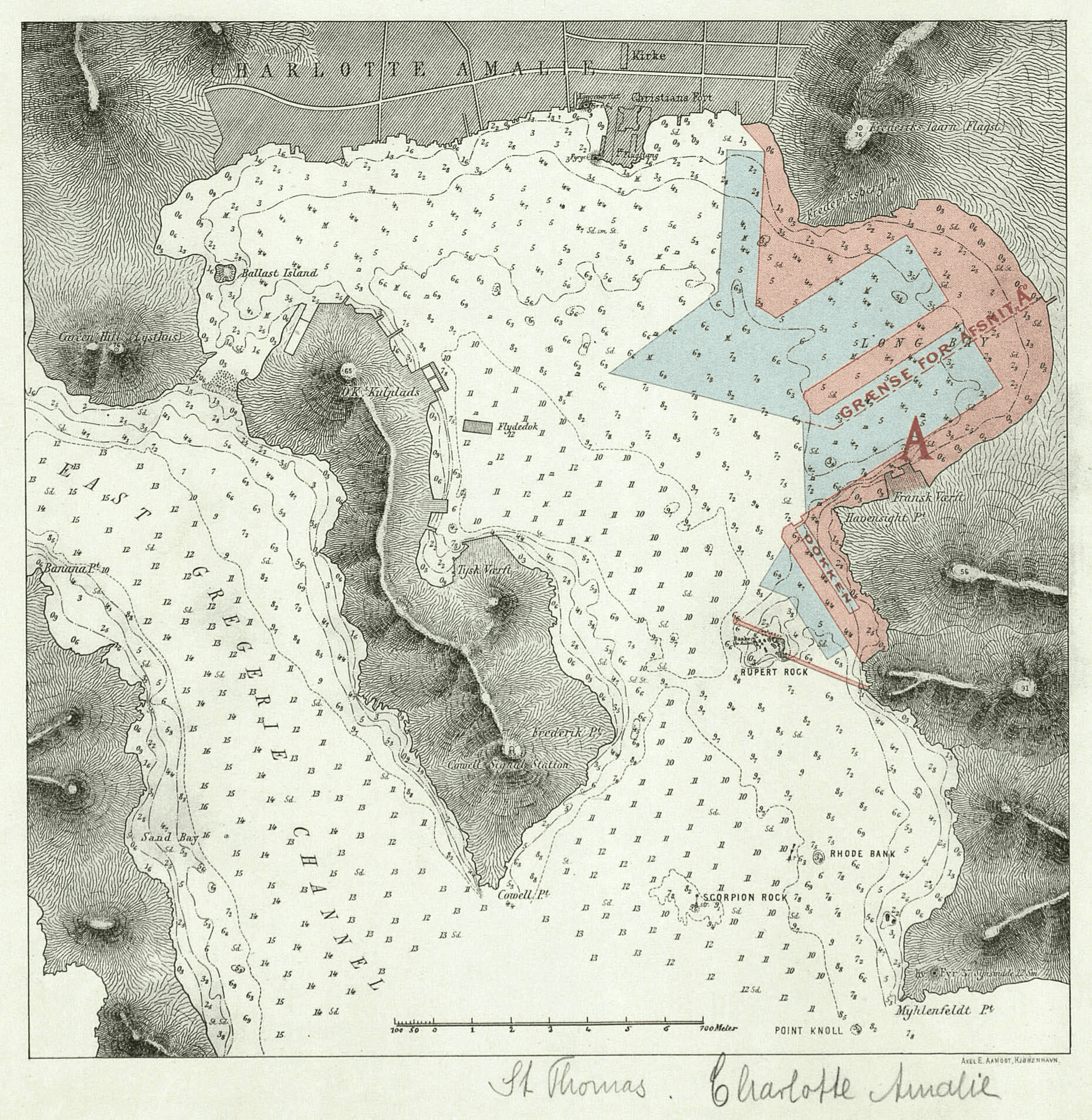
The Harbor Improvements
A 1912 map available at the National Museum of Denmark details proposed harbor improvements.
The ambitious plan incorporated the frontage of Bluebeard’s Hill; Long Bay (Dr. Mortensen’s property); French Wharf, Miss Knight’s property, Liverpool Wharf (all 3 are Havensight parcels); and even Rupert Rock which sits out in the harbor.
- The WICO dock finished in 1915 only included the development of Miss Knight’s property and French Wharf. Presumably, plans were scaled back due to a lack of capital or perhaps difficulty in acquiring rights to all the necessary properties.
- Other smaller wharves in the town of Charlotte Amalie are not labeled on the panoramic photograph. ‘King’s Wharf’ was the landing place for passengers coming into Charlotte Amalia.
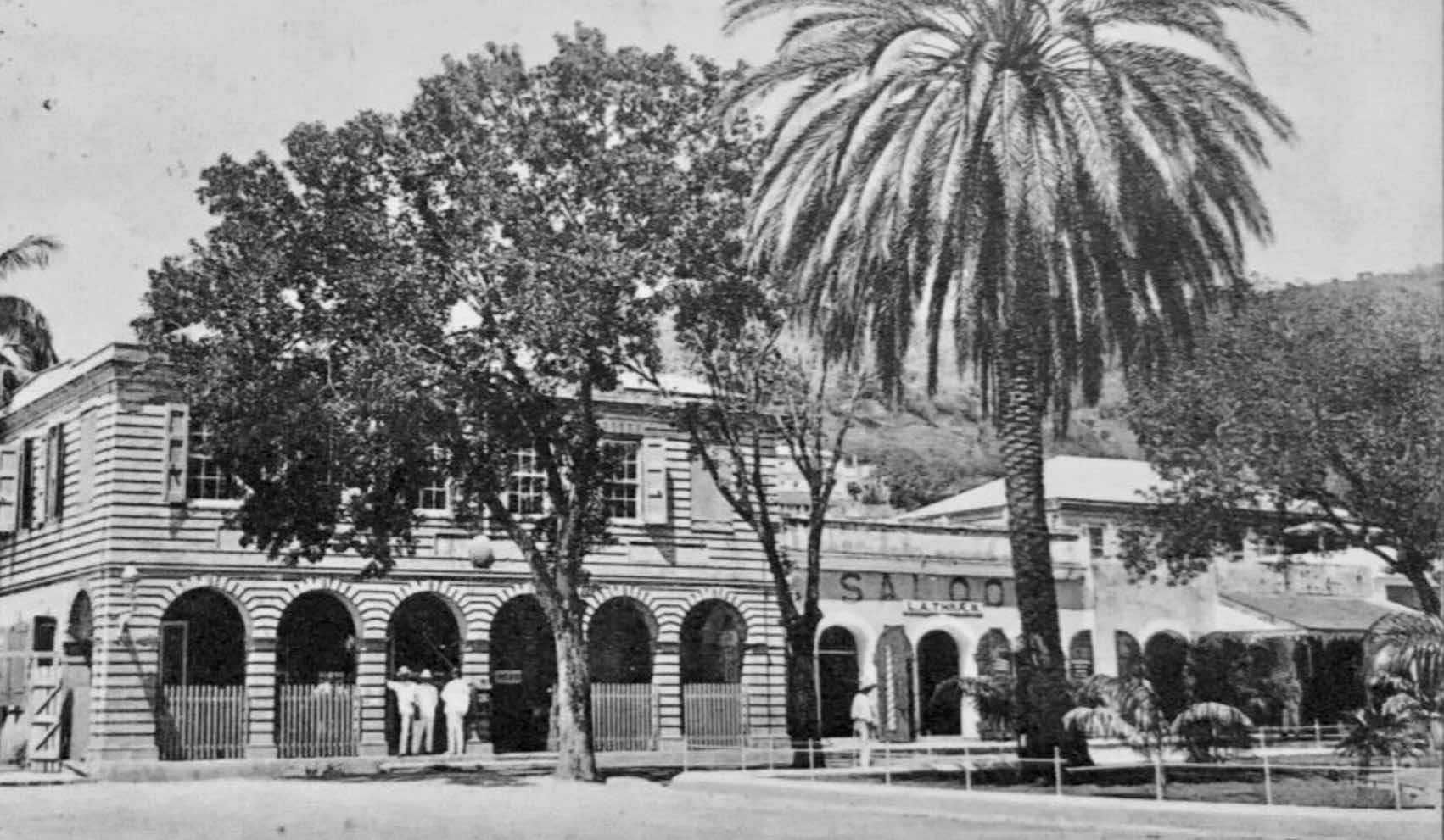
Also serving as a post office, the Custom House at King’s Wharf was a busy place.
- Some wharves were known simply by the proprietor: A. H. Riise, Fechtenburg, Creque, and Beretta wharves to name a few of the multiple small docks jutting out into the harbor from long warehouses on the south side of Main Street.
- These wharves were used to unload goods which were then shuttled up to the Main Street store or warehouse by porters or sometimes by means of a car on rails.
- The King’s Wharf and these smaller wharves went away with the construction of the Waterfront Drive in 1950.
Fraas would publish several versions of his photograph as postcards.
Hugo Larsen, a Danish artist who visited St. Thomas from 1904-1907 used this photograph to help create artwork for a poster after his return to Denmark.

Larsen also did at least one painting of the same motif of the harbor as viewed from Lawyer J.P. Jørgensen’s house at Mafolie estate during his stay in St. Thomas.
- Edward Fraas’ panoramic photograph of Charlotte Amalie’s harbor was used in souvenir booklets, photographs, and early postcards of the Danish West Indies.
- I suspect the picture was used to help in planning the West Indian Company dock that was finished in 1915.
- Illustrating a bygone era of panoramic photography, this iconic photograph offers insight into the bustling maritime activity of St. Thomas harbor in the mid-1890s.
In summary, the wharves in St. Thomas played a vital role in the island’s history and continue to be an important hub for shipping and trade today.
Thanks to these old photographs and the clues they left behind, we have learned how important the St. Thomas wharves were to the vibrancy and success of the maritime industry of the Danish West Indies.
-
Acknowledgments:Edward Fraas’ Panorama of Charlotte Amalia harbor with annotations is from the Maritime Museum of Denmark.
The photograph of WICO dock under construction is from this collection as well.Edward Fraas’ DeBeltjens panorama was sent to me courtesy of Peter Kelstrup, a Dane, who is a descendant of the Riise and Petit families of St. Thomas.The 1912 map of Charlotte Amalie harbor with proposed improvements is found at The National Museum of DenmarkHugo Larsen: Poster of Charlotte Amalia harborHugo Larsen: View from Mafoliehttps://www.tuxen.info/hugo_larsen/v8_eng.htm
Poster of Charlotte Amalia harbor
https://www.tuxen.info/hugo_larsen/v8_eng.htm
About the Author
Dr. Dante Beretta grew up in St. Thomas and now lives in Minnesota. He has been researching his Beretta and Dinzey family history which stretches back at least 200 years in the U.S. Virgin Islands. He’s interested in hearing comments on this story and from anyone interested in finding or indexing the records now available online at the Danish Archives. You may click on his name to send him an email message. To see additional stories by Dr. Beretta, visit this link ==>Beretta Family Stories
Thank you for this informative history. Important information as so much of the harbour has been reclaimed.
Dante
Thank you for this historical info on the wharves on St, Thomas. I always enjoy your writings. Looking forward to your continued research in which you so generously share.